Viewing an existing station
As e-FLORA-sys user you can view all of the stations registered in the database.
– Click on the “Stations” tab in the left menu.
– Input all or part of the name of the desired station in the dialog box “Search”. Then click on ‘search’ or press ‘Enter’ on the keyboard.
– The list of stations containing the search term appears. Click “View” to the desired station.
Create a station
Stations can be :
- Manually seized online
- Automatically created while importing a sample.
– You must be logged in to your account to create a new station.
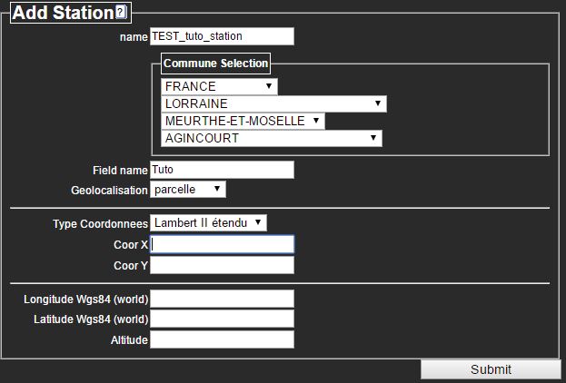
– Click the “Stations” tab in the left menu. Then click on “New Station”.
Each station is link to a geographic area and a field in which it lies. The information about the town and geolocation (coordinates) are required.
– Input an explicit station Name, in connection with the field (eg draine, undrained, testX_A, testX_N2K, No1, No2, Up, Down, etc.)
– The town selection (‘Commune Selection’) is guided : Country > Region > County > City.
– The field name is free. You can link multiple stations to the same field.
– Geolocation : Specify the location scale (city, field or station). The coordinates can be entered in the format :
- X,Y coordinates in Lambert II extended (3 decimal format – Eg X: 850803.593 – Y: 2405568.018) or ED50 (8 decimal format – Eg X: 5.98666600 – Y: 48.08674424)
- Longitude WGS84, Latitude WGS84 (6 decimal format – Eg Long: 5.986666 – Lat: 48.085927) and Elevation (from the field in meters – Eg 234)
It is possible to convert from one system to another with the website The World Coordinate Converter.
– Click ‘Submit’ to confirm.
– Your station is now created. A confirmation message appears at the top of the page.


